Walking Dinas Head, Pembrokeshire
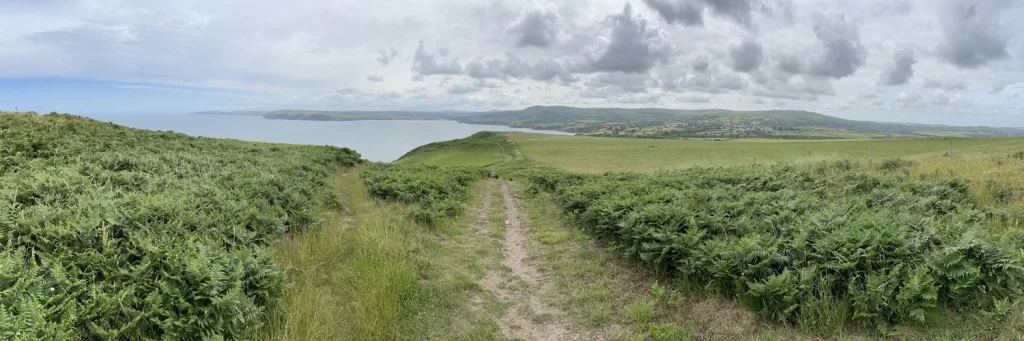
A short but stunning walk around the coastline of Dinas Head following the Wales Coast Path, with great views out to sea and of nesting seabirds, before returning via a flat, tarmac path through sheltered woodland. Activity type: Walk (but it would also make a fun trail run) Distance: 3 miles approximately Elevation: 169 metres (554 feet) of climbing (see Strava elevation for full profile) Accessibility: No styles, some sections are reasonably steep and have steps (see walk notes at the end for more info.) Route type: Circular Start/finish point: Car park at Cwm-yr-Eglwys, Pembrokeshire. Click View on Strava to check out the route and download the GPX file of the walk here. The steep road narrowed as we drove down into Cwm-yr-Eglwys, meaning Valley Church. The lane felt even more claustrophobic driving in late June as the hedgerow greenery leaned inwards until it touched the van on both sides. It reminded me a little of watching those Tour de France cyclists riding through an ever-narrowing tunnel of bodies on their exhausting Alpine ascents. It was early on a Monday morning, still term time, so the car park was almost empty except for one or two cars. As soon as we stepped outside, two things immediately came to our attention, a cold wind whipping off the sea and what looked like some sort of monument. Or was it a church or chapel of some kind? We donned a few extra layers – a shock to the system after such a warm day the day before – and dressed Lennie in his colourful new raincoat. Wandering past the inland boatyard with its small dinghies and the odd sailboat, the wind brought the familiar sounds of rippling cloth and the gentle clanging of buoy bells. Behind the boats, a gate led us through into a graveyard and what was obviously then the remains of a small church, now just a single wall topped with a tiny belltower and weather vane. An information board informed us that this had once been St Brynach’s, a 12th-century church, but two storms in the mid-19th century had washed away firstly much of the graveyard and then, in the great Charter Storm of 1859, most of the church as well. Just a few feet beyond the church, a small stone wall separated it from a fabulous little beach, benches offering a tranquil spot to sit and stare out to sea from the tiny, rocky cove. The scene was beautiful but also tinged with sadness, and the cold wind whipping in was a reminder that on worse days this narrow inlet would, and clearly had, acted as a funnel through which the wild weather reached the shore. Reading up about the village, it seems many villagers abandoned the place after the great storm. In more recent times, the desire for holiday homes in picturesque spots such as this meant that only one or two of the houses were now owned by people who lived there. For all its sadness and challenges, it remained a place of unquestionable beauty. Ferns as high as your head. Follow the acorns. Secret beaches perfect for pirates and smugglers. All that climbing was tiring! Views up top. The path winds on. I see the sea! And more sea! On the summit of Pen y Fan. After exploring the church ruins, it was time to get going. The route was a fairly easy one, taking the Wales Coast Path up and all the way around the headland. All we need to do was look for the familiar acorn signs that you’ll find on all national trails and walk. The climb started instantly as we left the village, weaving our way up through a sheltered gully with ferns higher than our heads lining the path on either side. Out of the wind and climbing continuously, we were soon too warm and the extra layers were quickly shed. Through gaps in the greenery we were treated to great views out beyond the cove to tiny, inaccessible beaches, the cliffs of the coastline snaking in and out into the distance, and beyond to the rugged hilltops of the Preseli Hills. The climb was definitely worth it though. A few minutes later, we were up on open heathland, the ferns up here a more normal height, fronds tickling your kneecaps as you brushed by. From here we had a panoramic view out to sea and along the coastline. The path clung to the side of the hills and cliffs, although it looked as if it may have been moved inland once or twice over the years as the wind and salt water had satiated its appetite for land, nibbling its way steadily into Wales. A little way along, Needle Rock towered upwards just a few metres out to sea. The stack was inhabited by thousands of nesting gulls and black and white sea birds, possibly razorbills or guillemots. A lack of binoculars and ornithology skills means I can’t confirm which. It could well have been both. The noise was deafening, the seabirds cackling like a coven of witches as we trod the path carefully towards the rock. The birds nesting and chatting up on Needle Rock. Past Needle Rock, the path continued to climb until we reached the summit and the furthest point of the headland at Pen y Fan. At 142 metres it’s not quite as high as its famous mountain cousin of the same name in the Brecon Beacons (now known by their traditional Welsh name, Bannau Brycheiniog), but it still offers fantastic views eastwards back towards Needle Rock, which now, from above, looks more like a tiny pimple, and west across Fishguard Bay to its eponymous ferry port. (Pen y Fan, by the way, means something along the lines of ‘top of this place’, hence why you’ll find quite a few of them around Wales.) The descent to Pwllgaelod began gently but became steeper as the path wore down into the earth until we
A wheelie wonderful weekend in Wales
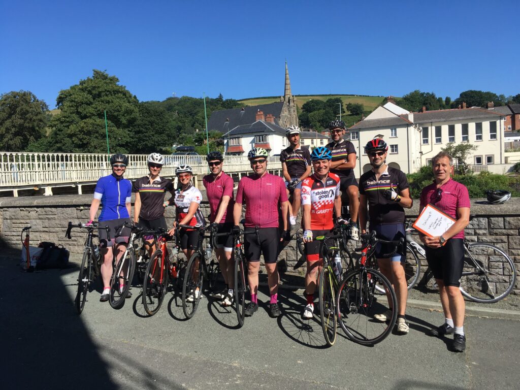
Click here to sign up to our newsletter and get weekly help to get fitter, healthier and happier The drive from Bristol to Wales on Thursday afternoon gave us a good indication of what was to come in the days ahead. The sun shone down from on high, intense and uninterrupted, not a cloud in the sky to stifle its powerful rays even for a second. After leaving the motorway, we wound through the farmland and rolling hills of Worcestershire, Herefordshire and Shropshire before crossing the border into Wales. Quiet villages full of crooked, centuries old buildings lined the route, interspersed by farmland, rivers, forests and panoramic hilltop views. We arrived into Newtown in late afternoon and after dropping Sam at her B&B, Vicky, Brian and I headed for our cottage. What greeted us was stunning, a collection of beautifully refurbished farm buildings surrounding the main house, a lake complete with fountain and even a couple of highly inquisitive llamas. A quick spot of unpacking and off into town to greet the arriving riders, get some dinner and watch England play Belgium. Unusually, we weren’t too fussed by the latter because somehow we’d already won our first two games and qualified, so the debate was more about whether we wanted to win to maintain momentum, or lose and possibly get into the easier side of the draw (which as it turns out, we definitely did). After a short briefing on the first day’s ride over dinner, everyone headed off for an early night ahead of the first day of cycling. Day 1 By 8:30 the following morning, our group of riders had amassed outside the Elephant & Castle Hotel in Newtown. The sun was shining, it was already warm and after a few bike tweaks, a little air in the tyres and the usual remembering someone had forgotten something, they were off. Brian and Simon rolling out on the front to pace everyone sensibly, Tom roving in the middle to ensure everyone was ok and Vicky at the rear ensuring nobody took a wrong turn and that everyone was supported. It was my turn to drive the van and I was excited to experience a day supporting in the Transporter. There’s an official balance one on the way later this year so we’d hired one for this trip and I was keen to see how useful it would be. Turns out, it’s amazing! The route wound along the valley on a quiet B road for 15 miles, following the river and surrounded on all sides by green hills. It was a pleasant and steady start for the group and it didn’t seem long before they’d made it over the first hill of the day to the water/feed stop in the market town of Llanidloes (roughly and poorly pronounced, Thlan-id-loice). Out of town and there was more climbing to do, this one long and in full sun but with great views of the valleys between the green peaks we were climbing. Driving along to catch up with the front riders, it appeared that the locals had decided to run a scrambling bike race on either side of the road, meaning that the riders had to join the main road and travel along for a good mile or two before continuing the race on the other side. With their race heads on, some were taking great risks cutting corners on the main road and I was pleased to hear Brian had given one of the organisers a piece of his mind. There’s a lot of information in Brian’s mind I might add, so I am sure the guy felt all the wiser for it! The vast majority started their descent down into the town of Rhayader and I headed back to help with the first mechanical issue of the day, a faulty inner tube valve, which was causing Alex’s tyre to constantly deflate. Vicky had waited for him so once we’d replaced it with a new one, they were off again. Tom had kindly waited for them in Rhayader so that they could work together on the climb into the Elan Valley. I drove off to head for a rendezvous-vous with the others at the lunch-stop but was quickly called back when Vicky rang to say her bike had broken. The hanger holding the rear mech (the thing that makes the gears change on the back cog) had snapped and it was unridable so she jumped in the van and Tom and Alex headed off again. Luckily there was a bike shop with the right parts literally round the corner and with Brian’s mechanical expertise, she was able to get up and running again and ride as support crew on the Sunday. Out of Rhayader and the road climbs at a constant but challenging gradient of around 8-10 per cent towards the Elan Valley. Built in the early 20th century, the dams that line the valley form a series of lakes that control the flow down from on high and still supply Birmingham with water to this day. Before the dams were built, the land was occupied by two large manor houses and a few small villages. All are now lost beneath the waters but you can discover more about them and their connection to the famous poet Percy Shelley, at the Elan Valley Visitor Centre. Once you reach the top of the climb, you enter a breath-taking moon-like landscape of heath, rivers and lakes. You can only imagine what it is like on a cold, windswept winter day; you probably don’t want to know for real. But cycling around it in glorious sunshine is well worth the effort of the climb, and you’re rewarded with a winding Alpine-like descent along the dam edges as you breeze effortlessly down towards the visitor centre. A quick lunch stop at the visitor centre and it was time to head north again, briefly following the main road before cutting across onto a National Cycle Route that hugged


